Urban Trek USA is an excellent resource for your San Francisco visit; providing self-guided directions for visitors to explore San Francisco like a long-time resident would, plus tips on whatever would be helpful to those who are visiting San Francisco.
Showing posts with label Urban-Trek-USA-Tips-Presidio. Show all posts
Showing posts with label Urban-Trek-USA-Tips-Presidio. Show all posts
This installment of things to do in San Francisco #TuesdayTips as part of #UrbanTrekUSATips features Baker Beach. Today actually has two tips but since I had previously posted about the Batteries to Bluffs Trail, I just updated that post and am adding this post on Baker Beach. Check out the Batteries to Bluffs Trail post as it complements Baker Beach.
Baker Beach is pretty well-known except maybe that there is a section of Baker Beach (closest to the Golden Gate Bridge) that is clothing optional. Therefore, if you have children you do not want to expose to nudity then be aware. If you like to sunbathe without clothing then this is one of the spots in San Francisco that allows you to do so (also refer to Marshall's Beach <see video towards the very bottom below> in the Batteries to Bluffs Trail post).
Baker Beach has an awesome view of the Golden Gate Bridge. The water is pretty much ice cold so swimming is not what most people do. Also the currents are very strong so be very careful when wading in the water.
In a prior #TuesdayTips post that I did on Lands End Trail, I mention one can walk from the Lands End Trail to Baker Beach and provided directions to do so. Therefore, if you want to walk to the Lands End Trail from Baker Beach, simply do the directions I provided previously in reverse order.
(Note: Public toilets are available in Baker Beach)
From Baker Beach you can also walk to the Golden Gate Bridge via the Coastal Trail. If you are fit, I recommend taking the Batteries to Bluffs Trail to get to the Golden Gate Bridge. By fit I mean you will have to go down a whole lot of steps and then have to go up a whole lot of steps on the other side. Also, the trail is narrow and a bit rocky. A few steps on the stairway are a little loose so be CAREFUL especially when going down the stairs.
To get to the Batteries to Bluffs Trail, walk up the path shown in the photo below. This is just before or just where the nude sunbathers are located.
(Click photo to enlarge)
If you do not want to walk close to where the nude sunbathers are located, take the path by the old batteries as shown in the photo below.
(Click photo to enlarge)
When you get to the part in the photo shown below, walk up the path.
(Click photo to enlarge)
When you get to the top where Lincoln Blvd. is (Coastal Trail), make a left until you see the sign in the photo below.
(Note: When walking from Baker Beach towards the Golden Gate Bridge, this sign is facing a little bit the other direction so make sure you are looking for this sign on your left side.)
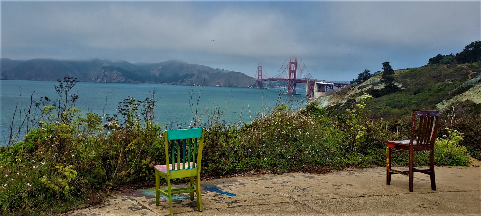
Walk down the stairs and stop whenever you want to admire the beautiful view. If these chairs are still on one of the old batteries, check them out:
(Click photo to enlarge)
Also, this is very interesting about the field note for this area:
(Note: For more information about the field notes in various places in the Presidio, click here.)
If you want to visit Marshall's Beach, watch out for the sign in the photo below and walk down the path.
(Click photo to enlarge)
Note: As mentioned earlier, Marshall's Beach is a clothing optional beach.
From Marshall's Beach, backtrack to the Batteries to Bluffs Trail and make a left and go up the steps. Before you get to the top, stop by this bench that you will see on your left (a little bit hidden) that has a pretty nice view:
(Click photo to enlarge)
After, walk up to the top where the Coastal Trail meets the Batteries to Bluffs Trial. Turn left on the Coastal Trail, which will lead you to the Golden Gate Bridge.
(Note: I personally would do the Lands End Trail to Baker Beach to Batteries to Bluffs Trail to Golden Gate Bridge to Crissy Field to Marina Green to lower Fort Mason to upper Fort Mason. Or if you want to split into two, then Lands End to the Golden Gate Bridge and then upper Fort Mason to Crissy Field. The directions were done the way they are because most people are coming from the Fisherman's Wharf area and not the Lands End Lookout area.)
The Batteries to Bluffs Trail is a trail that goes up and down the hillside (bluffs). Therefore, you will have to be fit to do this trail or you will have to keep resting especially on the way up. On a clear day, you will have a great view of the Golden Gate, Pacific Ocean, Golden Gate Bridge and the Marin Headlands. Most of the year, it will be windier and colder in this area so dress accordingly.Click this link for more information about the Batteries to Bluffs Trail.
This self-guided instructions for the Batteries to Bluffs Trail can be done in conjunction with the instructions for the Lands End Trail and then hike all the way to the Golden Gate Bridge. If you do the Lands End Trail first (see the Mar. 5, 2018 post, updated July 19, 2021), you will have to do the Batteries to Bluffs Trail instructions backwards because the Batteries to Bluffs Trail directions starts from the Golden Gate Bridge area. If you do the Batteries to Bluffs Trail directions first then you will have to do the Land End Trail directions backwards.
Note: If I were to do both the Lands End and Batteries to Bluffs trails, I would start with the Lands End Trail and then after Baker Beach hike the Batteries to Bluffs trail and then walk to the Golden Gate Bridge. If you follow this suggestion, I also recommend that you get to the Golden Gate Bridge no later than 2:00 pm so you can take nicer pictures because of where the sun is positioned. Depending on how fast you hike and how long you want to linger at certain spots, I think you will have to start from the Lands End Lookout by 12:00 pm because according to Google Maps, it will take most people 1 hour and 13 minutes to walk approximately 3.4 miles from the Lands End Lookout to the Golden Gate Bridge.
Also, for other things to do in the Presidio, click on the label = Urban Trek USA Tips Presidio. And for specifically just the hiking trails in the Presidio,click on the label =Presidio Trails.
Note: Pdf version of directions available upon request.
From the Golden Gate Bridge walk south along the Coastal Trail. After you pass Battery Godfrey, you will see this marker:
(Click photo to enlarge)
Continue walking south along the Coastal Trail until you see this garbage can and the sign for the start of the Batteries to Bluffs Trail on your right side:
(Click photo to enlarge)
Go down the stairs and look on your right side for this bench (a little bit hidden) that has a pretty nice view:
(Click photo to enlarge)
Go back to the trail and keep walking down until you see the sign for Marshall's Beach:
(Click photo to enlarge)
Turn right when you see the sign and walk down to Marshall's Beach (Note: Marshall's Beach is a clothing optional beach so if you are with children and you do not want them to see naked people then do not go unless there are no naked people there.)
After you enjoy the view from Marshall's Beach, walk back to Batteries and Bluffs Trail and turn right. There will be several spots with nice views so make sure you look back towards the Golden Gate Bridge every now and then.
As you are headed up the hill, watch out for this interesting Field Note:
(Click photo to enlarge)
Note: There are several Field Notes around the Presidio. For more information about them, click here.
Continue on up until you get to Battery Crosby. If these chairs are still there, check them out:
(Click photo to enlarge)
After Battery Crosby, keep going until you get to the Coastal Trail where Lincoln Blvd. is and turn right.
Keep walking along the Coastal Trail (Lincoln Blvd) until you pass this sign:
(Note: Do not take Sand Ladder to Baker Beach unless you want to see the naked people.)
After you pass the sign above, you will see another trail on your right that will lead you to Baker Beach. When you get to this point follow the trail to the left to the G rated part of Baker Beach:
(Click photo to enlarge)
Go own this path to the beach:
(Click photo to enlarge)
PLEASE READ: If you do not want to proceed to the Lands End Trail and want to go back downtown, the Muni #29 bus has a bus stop at the upper entrance to Baker Beach. You will have to walk to the gate at Gibson Rd and Bowley St and there will be a bus stop as shown below:
(Click photo to enlarge)
Take the Muni #29 bus to 25th Ave. and California St. (Note: This is the fourth stop from where you will start so it will be a short ride.)
After you disembark, cross to the other side of California St. so you will be where the gasoline station is located. There will be a bus stop for the inbound Muni #1 bus (Stop ID 13840). Take the Muni #1 bus headed to Drumm & Clay. The Muni #1 bus will pass the Inner Richmond, Laurel Heights, Presidio Heights, Pacific Heights, Nob Hill, Chinatown and Financial District neighborhoods so you can disembark wherever you want to go.
Another way to get to downtown is via the PresidiGo Presidio Hills & Downtown shuttles. Due to the pandemic, it seems service have been (temporarily?) discontinued on weekends. Click here to the web page showing the service cut announcement. Hopefully, weekend services will resume when things go back to pre-pandemic days.
These are the two PresidiGo Presidio Hills shuttle stops near Baker Beach as shown in the photo below:
(Click photo to enlarge)
Take the Presidio Hills Shuttle to the terminal in the Presidio and then take the Downtown shuttle to go downtown. Outside the Presidio, the Downtown shuttle stops at Van Ness & Union, Davis & California Streets (near the Hyatt Embarcadero) and SF Transit Center (Howard & Beale Streets).
Click here for PresidiGo shuttle Rider Guide and other important information like when visitors are allowed to ride for free and when visitors are not allowed to ride. (Note: The Muni #43 bus does NOT go to the Presidio at this time (as of August 16, 2021) but that might change when things get back to pre-pandemic days.)
(Note: I personally would do the Lands End Trail to Baker Beach to Batteries to Bluffs Trail to Golden Gate Bridge to Crissy Field to Marina Green to lower Fort Mason to upper Fort Mason. Or if you want to split into two, then Lands End to the Golden Gate Bridge and then upper Fort Mason to Crissy Field. The directions were done the way they are because most people are coming from the Fisherman's Wharf area and not the Lands End Lookout area.)
The Lands End Trail, on a clear day, has a super gorgeous view of the Pacific Ocean, the Golden Gate and the Golden Gate Bridge. I believe you have to be reasonably fit to be able to hike the trail because of the up and down terrain. You will have to be more fit if you go to Mile Rock Beach because you will have to go down a pretty steep slope and then go back up that same hill. However, the Lands End Trail is still worth doing even if you are not able to go down to Mile Rock Beach.
I recommend starting from the Lands End Lookout and walk towards the Golden Gate Bridge because the view is better that way (heading to the Golden Gate Bridge) instead of going the other direction (away from the Golden Gate Bridge). If you hike from the Golden Gate Bridge to the Lands End Lookout, just make sure you look back every now and then for the view.
IMPORTANT: Fog can play an important role (a bad one) in your enjoyment of hiking the Lands End Trail because you will not see much if it is foggy. I recommend checking before you head out to see whether or not it is foggy. However, fog can come and go just like that so the morning can start as foggy but the fog can burn by noon. Summer has more fog than fall and winter. What I recommend is to check the webcam at Crissy Field(here), and you can point the webcam to the Golden Gate Bridge. If there is fog at the Golden Gate Bridge then most likely there will be fog at the Lands End Trail. Refer to photo below with some instructions on how to use the Crissy Field webcam:
(Note: You can change the preset view only when "Controls available" is showing in the box at the lower left of the screen.)
(Click on photo to enlarge)
Note:If it looks like the Crissy Field webcam noted above is temporarily out of service, click here for the webcam at the Golden Gate Bridge itself
What to wear: The temperature between downtown San Francisco and the Lands End Trail area can be 5 to 10 degrees F colder because of the wind and water. Therefore, I strongly recommend that you dress for (or are prepared for) colder temperature (i.e. dress in layers so you can add or remove as needed).
Directions for exploring the Lands End Trail:
The Muni #38 and #38R buses all go close to the Lands End Lookout. The bus stop closest to Union Square in the one at Geary Blvd (corner Powell) where the Westin St. Francisco Hotel is located. Take one of those buses to the very last stop at 48th Avenue & Point Lobos. (Note: There are #38 buses that go to the VA Hospital or Balboa & 33rd Avenue. These routes will NOT go to 48th Avenue. Therefore, make sure you ask the driver if the bus goes to 48th Avenue. If you happen to take the bus that does not go to 48th Avenue, just get off the bus at Geary and 33rd Avenue and then wait for the #38R or #38 that goes all the way to 48th Avenue & Point Lobos.)
Possible Detour:
- When you get off the bus at 48th Avenue & Point Lobos, you will be near the entrance to Sutro Heights Park. You can wander around the park where you will have a nice view of Ocean Beach if it is not foggy.
- If you want something to eat before hiking the Lands End Trail, check out Louis’ at 902 Point Lobos Avenue, just a bit down the hill form the Lands End Lookout. The food is good and some booths have a great view of the Pacific Ocean.
(Video of what you can see at Sutro Heights Park)
After you get off the bus, walk towards Point Lobos Avenue and cross to the other side of the street. Make sure you use the marked crosswalk and be cautious when crossing. You will see the Lands End Lookout after you cross Point Lobos Avenue. You can check out the exhibits, which will give you some historical information about the area, if it is open. You can also grab something to eat at the café and/or use the public toilets if they are open. If it is closed, you will not be able to use the public toilets and there will be no other place to use a toilet nearby so keep this in mind.
As of May 14, 2023, these are the operating hours for Lands End Lookout:
(Click on the photo to enlarge)
You can double check the hours of operation here in case there has been a change.
This is what you will see from the Lands End Lookout:
Possible Detour:
- You can walk down the hill to the Sutro Bath ruins if you like before starting your hike of the Lands End Trail. Just note that you will have to walk back up the hill if you walk down.
Follow the trail signs. Note that the Lands End Trail is part of the Coastal Trail so don’t be confused if the sign shows “Coastal Trail.”
(Click on photo to enlarge)
As you go further along the Lands End Trail, this is what you will see:
Possible detour:
- When you get to the Eastern Coastal Trail Overlook you will see stairs leading up to the USS SF Memorial. This is how the stairs look from above:
(Click on photo to enlarge)
- If you go up the stairs to the USS SF Memorial, this is the best view from the top by the parking area:
(Click on video to enlarge)
As you walk past the Eastern Coastal Trail Overlook, this is what you will see:
(Click on video to enlarge)
Possible Detour: - When you see this sign, you can go down the steps to Mile Rock Beach:
(Click on photo to enlarge)
(Click on photo to enlarge)
- Mile Rock Beach is worth seeing but you will have to walk down the hill and then walk back up the hill. Make sure you look for the sign showing the stairs that will lead to Mile Rock Beach. This is what you can see at Mile Rock Beach:
(Click on video to enlarge)
Additional information with regard to the labyrinth that used to be at Mile Rock Beach:
Read:This article from August 14, 2021 is about the destruction of the Lands End labyrinth. I am sad and very infuriated that people would do such a thing. Hopefully, it will be resurrected in the future.
Additional reading:This article from January 24, 2022 is about two people who attempted to rebuild the labyrinth but found out that they would not do it so installed something else instead, which I think is a good substitute.
Here is a video of what you can expect to see as you walk the rest of the Lands End Trail until Lincoln Park:
After the Lands End Trail:
When you get to the end of the Lands End Trail, you will be at the entrance to Lincoln Park. From that
point, you have the following choices:
A: You can visit the Legion of Honor Museum. To do so, walk up hill along El Camino Del Mar.
B: Go back downtown. To do so, walk south on 32nd Avenue to California Street. There is a bus stop at
the southeast corner of 32nd Avenue & California Street for the Muni #1 bus. Take the #1 bus which
will pass the Outer & Inner Richmond, Laurel Heights, Pacific Heights, Nob Hill, Chinatown and
Financial District neighborhoods. (Possible Detour: You can stop at Pacific Heights. If you get off at Sacramento & Fillmore,
Fillmore Street between Jackson Street and Sutter Street is lined with high-end boutiques,
restaurants & cafes (refer to list provided to you of Urban Trek USA’s favorite restaurants in
Pacific Heights). You can also use the instructions for exploring Pacific Heights if you get off at
Sacramento & Octavia.
C: You can walk all the way to Baker Beach. To do so, walk east along the El Camino Del Mar and then
turn left at Sea Cliff Avenue. Make sure you turn left when you reach the fork on the road when the road
splits between El Camino Del Mar and Sea Cliff Avenue as shown in the photo below:
(Click on photo to enlarge)
Keep walking on Sea Cliff Avenue to 25th Avenue. Turn left on 25th Avenue until the end where you
will see a gate that will lead you to Baker Beach. Refer to photo below showing the gate:
(Click on photo to enlarge)
For some information about Baker Beach with videos, photos and more directions, click here.
From Baker Beach:
1) You can take an easier walk directly to the Golden Gate Bridge if you follow the Coastal Trail.
3) You can go toPresidio Tunnel Tops and Presidio Transit Center by taking the FREE PresidiGo South Hills shuttle. There are two stops near Baker Beach: one at Lincoln Blvd & Pershing Drive <stop #10> and one at the 25th Avenue stop at Lincoln
Blvd & Lobos Valley <stop #9>. Refer to PresidiGo South Hills shuttle map below:
(Click on photo to enlarge)
(Video of what you can see at Presidio Tunnel Tops)
PLEASE READ: The last part of the directions mention the PresidiGo South Hills shuttle. Click here to the web page showing the South Hills shuttle schedule plus information on the Downtown shuttle. The Downtown shuttle is also free on weekends and certain times on weekdays. Check the website for details. The Downtown shuttle has two stops downtown: Drumm & California Streets and the Transbay Terminal at Howard & Beal Street. Therefore, the Downtown shuttle is an option for you if you want to visit Tunnel Tops and then go back downtown.
Also, for other things to do in the Presidio, click on the label = Urban Trek USA Tips Presidio. And for specifically just the hiking trails in the Presidio, click on the label = Presidio Trails.
(Note: I personally would do the Lands End Trail to Baker Beach to Batteries to Bluffs Trail to Golden Gate Bridge to Crissy Field to Marina Green to lower Fort Mason to upper Fort Mason. Or if you want to split into two, then Lands End to the Golden Gate Bridge and then upper Fort Mason to Crissy Field. The directions were done the way they are because most people are coming from the Fisherman's Wharf area and not the Lands End Lookout area.)